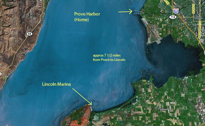
I was out sailing earlier this summer under a full moon and 10 knot winds. Beautiful night for sailing. I sailed from the Provo Harbor about 7 miles to the southwest, just sailing “wherever the wind blew.” And then the winds kicked up considerably, clouds covered the moon, and the waves started getting a little uncomfortable. I couldn’t see anything. And the wave/wind combination was so strong that I couldn’t leave the cockpit to go below for my spotlight.
 I knew there was an old marina about 2 miles south, and even had it marked on my GPS. No problem, I decided I better spend the night there rather than try and make it to home port that night.
I couldn’t see anything, the night was completely black under the clouds. The “marina” was used for launching small trailered fishing boats, and did not have any working beacons or useful lights.
By the GPS, I was headed straight into the opening between the jettys. But as I got closer, the sound of waves smashing into the rocks all around me told me that my coordinates were perhaps off by a bit. I was nowhere near the opening.
I moved away from the shore to figure things out. The waves were too big to spend the night at anchor, there were no boats in the area, and I was too tired by then to try and make it to another safe harbor.
 And then it dawned on me. I pulled out my cell phone (an AT&T Tilt) which had a GPS on it. The other thing it has is an interface to google satellite imagery. Within a minute, it had acquired, and accessed the cell tower to download the google satellite image.
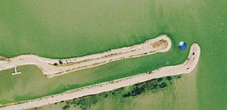
The great thing about the satellite image was that it had been taken in the daytime, so I could clearly see the jetty, with my position superimposed on the image. I motored back towards the jetty, staring desperately at my cell phone screen and listening for the break in the crashing waves. After a minute, there it was! The picture above is what I saw on the GPS. Winds were coming from the northwest (top left). You can zoom in a lot closer than what is shown here, I took the screenshot zoomed out to show the entire length of the little marina.
The jetty opening was only about 15 feet wide (actually a little wider, but when a sailboat sails into a recreational fishing marina, you can only use the center of the channel because the keel drafts much deeper than those fishing boats…) There was no way I would have made it in the dark. (My GPS coordinates had been about 100′ off.)
I slipped right into the little empty marina, watching the small blue dot move along the satellite image right up to the empty dock. I spent a very relaxed night listening to the waves crash against the jetty, thankful that I wasn’t experiencing the sound from the other side of the wall…
This is a great emergency navigational tool, and it is probably available around most lakes and coastal cruising areas – anywhere you can get cell phone reception the phone can superimpose google’s satellite photos. The best part is, AT&T charges a monthly fee for the satellite image services, OR… you can download a plugin free from google.
Follow this link for the discussion on the Catalina Owners Association forums:
catalina-capri-25s.org/forum/topic.asp?TOPIC_ID=18703
Here’s the google page with more information. The service is free from Google (you will use your data plan on your cell phone though)
http://www.google.com/mobile/default/maps/index.html
Looks like it works on just about any phone operating system:
“Google Maps for mobile works on most phones, including those that run the below platforms. You can always download Maps to your phone using your cellular connection — just visit m.google.com/maps on your device’s browser, or send yourself a text message using the button at the top of this page. Some mobile phones also support the ability to sideload Google Maps onto your phone.
* BlackBerry
* Java
* Windows Mobile (download binary)
* Symbian S60 3rd Edition (most new Nokia smartphones) (download binary)
* Palm OS (download binary)
* iPhone (pre-installed)
“
